

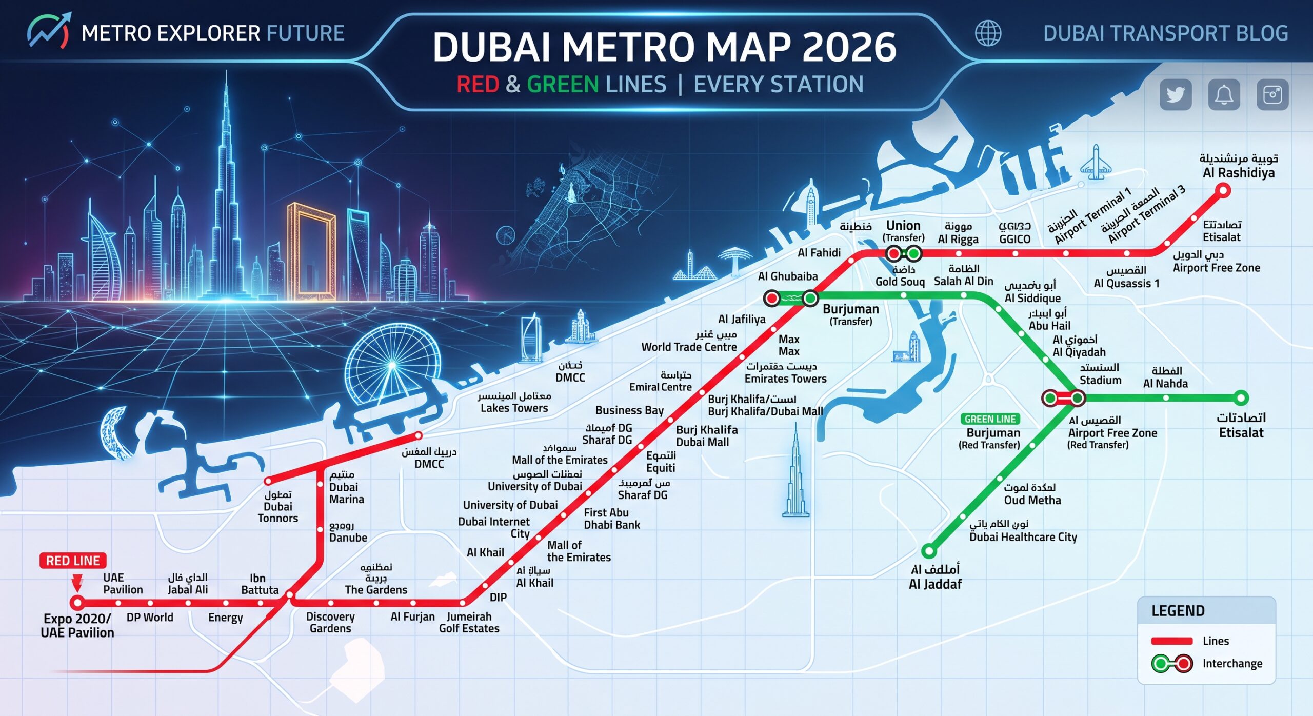
Fifty stations, two lines, and one map that decides how fast you actually get across Dubai. If you have ever stood at a platform trying to work out whether you need to change trains at Union or BurJuman, you already know why the Dubai Metro map matters more than it looks.
This guide breaks down the full Dubai Metro map for residents: every station on the Red Line and Green Line, the two interchange points, how the zones overlay onto the map, and what has changed for 2026, including the newly announced Gold Line.
In this guide you will learn:
- The complete station list for the Red Line and Green Line
- Where the two lines cross and how to change trains
- How fare zones are laid out across the map
- What the Blue Line and Gold Line additions mean for future commutes
- Which stations sit closest to major residential and business areas
Let’s map it out properly.
Table of Contents
- What Is the Dubai Metro Map
- Why the Dubai Metro Map Matters in 2026
- Red Line Stations: Full List
- Green Line Stations: Full List
- How to Switch Lines: Interchange Stations
- Reading the Zone Layout on the Map
- What Is Changing: Blue Line and Gold Line
- Common Mistakes When Reading the Map
- FAQ
What Is the Dubai Metro Map
The Dubai Metro map is defined as the official route diagram showing all stations, lines, and interchange points across Dubai’s driverless rail network, operated by the Roads and Transport Authority since September 2009. It shows two operational lines, the Red Line and the Green Line, along with the fare zone each station falls into.
The network spans close to 90 kilometers of fully automated track and connects around 50 stations, running from Centrepoint in Rashidiya on one end to Expo City on the other, with the Green Line running separately from Etisalat to Creek.
Pro Tip: Download the official RTA metro and tram map PDF from rta.ae before your first few rides. It is more detailed than most third party maps and gets updated whenever a station changes name or a new line is confirmed.
Why the Map Looks Confusing at First
New residents often assume the Red Line and Green Line cross at multiple points, when in fact they only meet at two stations. Once you know those two points, the entire map becomes far easier to navigate.
Why the Dubai Metro Map Matters in 2026
The Dubai Metro map matters in 2026 because the network is entering its biggest expansion phase since it opened. A Gold Line was announced in April 2026 with an investment plan targeting a 2032 opening, adding to the previously announced Blue Line, which is expected to begin operations around 2029.
Quotable insight: A resident who understands the current map today will have an easier time adapting once the Blue Line and Gold Line stations start appearing on it over the next several years.
More Than Just Metro
The same RTA network map also shows tram stations, which matters for anyone living in Dubai Marina or Jumeirah Beach Residence, since the tram connects directly into two Red Line metro stations.
Red Line Stations: Full List
The Red Line is the longest and busiest line on the Dubai Metro map, stretching approximately 52 to 67 kilometers depending on how the Route 2020 branch to Expo City is counted, and running largely parallel to Sheikh Zayed Road.
Here is the direct answer: the Red Line runs from Centrepoint in the east through the main Sheikh Zayed Road corridor to UAE Exchange and Expo City in the west, covering 35 stations including the Route 2020 branch.
Key Red Line Stations for Residents
- Centrepoint (formerly Rashidiya): Eastern terminus, feeder buses connect to residential areas nearby.
- GGICO: Close to Dubai Creek Golf and Yacht Club.
- Al Rigga: Busy commercial area with hotels and restaurants.
- Union: Interchange station, connects to the Green Line.
- BurJuman: Second interchange station, adjacent to BurJuman Mall.
- Max (formerly Al Jafiliya): Near Zabeel Park and Dubai Frame.
- Business Bay: Serves the Business Bay commercial district.
- Burj Khalifa / Dubai Mall: Closest station to Downtown Dubai’s main attractions.
- Dubai Internet City: Serves Barsha Heights and nearby tech offices.
- DMCC (formerly Jumeirah Lakes Towers): Connects to JLT and the Dubai Tram.
- Ibn Battuta: Near Ibn Battuta Mall and Discovery Gardens.
- Jabal Ali: Interchange between the main Red Line and the Route 2020 branch.
- Dubai Investment Park: Serves the DIP residential and industrial community.
- Expo City: Western terminus on the Route 2020 branch.
Green Line Stations: Full List
The Green Line runs through Dubai’s older, more established districts and is shorter than the Red Line, covering around 15 stations across roughly 22.5 kilometers.
The direct answer: the Green Line runs from Etisalat in Al Qusais to Creek in Al Jaddaf, passing through Deira, Bur Dubai, and Al Karama along the way.
Key Green Line Stations for Residents
- Etisalat: Northern terminus of the Green Line.
- City Centre Deira: Direct access to City Centre Deira Mall.
- Union: Interchange with the Red Line.
- BurJuman: Second interchange with the Red Line, near Al Seef.
- ADCB: Serves the Al Karama residential and market area.
- Al Fahidi: Close to the historic Al Fahidi district and Dubai Museum.
- Creek: Southern terminus, near Dubai Festival City.
Pro Tip: If your destination sits near the Gold Souk, Spice Souk, or Al Fahidi Historic District, the Green Line will almost always get you closer than the Red Line.
How to Switch Lines: Interchange Stations
Dubai Metro Map Comparison: Interchange Stations at a Glance
| Station | Lines Connected | Nearby Landmark | Typical Wait Time | Rating |
|---|---|---|---|---|
| Union | Red Line and Green Line | Al Ghurair Centre, Dubai Creek | 2 to 4 minutes peak | 4.6/5 |
| BurJuman | Red Line and Green Line | BurJuman Mall, Al Seef | 2 to 4 minutes peak | 4.5/5 |
| Jabal Ali | Main Red Line and Route 2020 branch | UAE Exchange, Expo City direction | 5 to 7 minutes off peak | 4.3/5 |
Winner for most residents: Union Station, since it sits closer to central Deira and Bur Dubai and generally has shorter walking distances between platforms compared to BurJuman.
Step by Step: Switching Lines at Union or BurJuman
- Exit your train at Union or BurJuman station.
- Follow the signage toward the connecting line, Red or Green depending on your direction.
- Tap again if required based on your fare zone crossing, though most transfers do not require a new tap.
- Board the connecting train heading toward your final destination.
Dubai Metro: The Complete Guide for Residents in 2026
Reading the Zone Layout on the Map
The Dubai Metro map overlays a zone system on top of the physical route, and this is what actually determines your fare, not the number of stations you pass through.
Zone boundaries generally follow geographic clusters rather than line boundaries, meaning both the Red Line and Green Line pass through multiple zones. A trip from a western Red Line station like Ibn Battuta into the central Business Bay or Dubai Mall area will typically cross at least one zone boundary.
Why This Matters When Reading the Map
Two stations that look close together on the printed map can sometimes sit in different fare zones, so it is worth checking the zone number printed next to each station name rather than judging distance by eye alone.
What Is Changing: Blue Line and Gold Line
The Dubai Metro map is set to grow significantly over the next several years. The Blue Line, announced with an investment of AED 18 billion, is expected to open around 2029 and will extend from the Red Line’s Centrepoint terminus and the Green Line’s Creek terminus, adding roughly 14 new stations including three interchange points.
A Gold Line was separately announced in April 2026, planned as a further extension with an expected opening around 2032, adding additional stations to the network beyond the current Red and Green Line footprint.
Original analysis: Based on current announced routes, residents living along the eastern and northern edges of the current network stand to benefit most from the Blue Line, while any resident whose commute currently requires a long bus connection to reach the nearest metro station should watch Gold Line station announcements closely over the next few years.
Common Mistakes When Reading the Map
- Assuming the lines cross more than twice: They only meet at Union and BurJuman.
- Judging fare by station count instead of zone: Two stops can cross a zone boundary while five stops within the same zone might not.
- Confusing old and new station names: Several stations, including Centrepoint and Max, were renamed from Rashidiya and Al Jafiliya, and older maps online may still show the previous names.
- Ignoring the Route 2020 branch: Trains heading toward Expo City split off from the main Red Line at Jabal Ali, so check the destination board before boarding if you are headed that way.
FAQ
What is the Dubai Metro map?
The Dubai Metro map is the official route diagram showing every station across the Red Line and Green Line, along with the fare zones and interchange points connecting the two lines. It is published and updated by Dubai’s Roads and Transport Authority.
How many stations are on the Dubai Metro map?
The Dubai Metro map currently shows around 50 stations combined across both lines, with the Red Line covering roughly 35 stations, including the Route 2020 branch, and the Green Line covering about 15 stations.
Why does the Dubai Metro map show two interchange stations?
The Dubai Metro map shows Union and BurJuman as interchange stations because these are the only two points where the Red Line and Green Line physically connect, allowing riders to switch lines without leaving the paid area.
Is the Dubai Metro map going to change soon?
Yes, the Dubai Metro map will change over the next several years as the Blue Line, expected around 2029, and the newly announced Gold Line, expected around 2032, add new stations and routes to the existing network.
What is the best way to read Dubai Metro zones on the map?
The best way is to check the zone number printed beside each station name rather than estimating by distance, since fare zones follow geographic boundaries that do not always match visual spacing on the map.
Can the Dubai Metro map help me find stations near shopping areas?
Yes, many Dubai Metro stations sit directly beside major landmarks, including Burj Khalifa and Dubai Mall station in Downtown, BurJuman station near BurJuman Mall, and City Centre Deira station near City Centre Deira Mall.
What is the difference between the Red Line and Green Line on the map?
The Red Line runs largely parallel to Sheikh Zayed Road through business and tourism districts, while the Green Line loops through older residential areas including Deira, Bur Dubai, and Al Karama. They only connect at Union and BurJuman.
How much does it cost to travel across zones shown on the Dubai Metro map?
Cost depends on how many zones a journey crosses rather than which line is used. A Nol Silver Card charges from around AED 3 for a single zone trip up to AED 7.50 for journeys crossing more than two zones.
Conclusion
The Dubai Metro map looks complicated at first glance, but it really comes down to two lines, two interchange points, and a zone system layered on top. Once you know where Union and BurJuman sit and which zone your regular stations fall into, planning any route across Dubai becomes straightforward.
Next Steps:
- Save the RTA metro map PDF to your phone for offline reference
- Identify which zone your home and work stations fall into
- Keep an eye on Blue Line and Gold Line updates if you live near the planned expansion areas
